ImportGEO
Importing data to 3ds max is fundamental to try to reproduce the real world in 3d environment.
I made two scripts SPline CSV IO (Import/Export) and Import Geo.
SPline CSV IO can import or export data to/from regular CSV file.
Import Geo can import geographic coordinates (longitude,latitude and Altitude).
The coordinate system is the same of Google Earth ( WGS84; EPSG:4326 ). The cordinates are in decimal format (Long , Lat) Altitude are in meters.
For Download & Install go to Home section.
How to Use: Go to “utilities” tab (hammer) –> MAXscripts->Utilities
This script needs a register file to work to receive the file I ask a small donation.
After you install and try to open you get a window with your MachineID send this (with spaces) to mmoraisdois@gmail.com to receive instructions to activate.
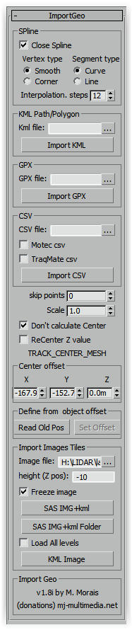
Import Geo
When import the script move points to center of 3DS MAX. After import the script create a hidden object “TRACK_CENTER_MESH”. This object don’t have points only store the center of imported data. Why this? because when you import other data they will match with the existing ones.
When open the script if the object “TRACK_CENTER_MESH” exist will take center saved in the object.
Options and Functions.
skip points: Define the number of points to skip.
Scale: Scale coordinates ( 1.0 = 100%)
[] Don't calculate Center: If checked the script don't create center mesh.
[] ReCenter Z value: If checked calcualtes center for Z values (altitude).
SPline CSV IO
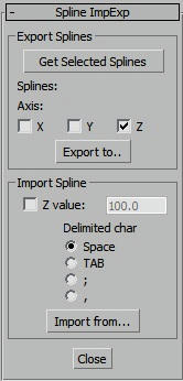
This scrip import/Export regular CSV files. Are text files with columns of data separated by commas, semicolon or spaces.
Export Splines
Select splines and press “Get Selected Splines”
Axis: check axis to export
Import Spline
Z value: If checked the Z value is for of all spline (flat).
Delimited char: Is the character used for separation columns.
Install: Copy files to <MAXdir>/scripts/startup
How to
Use: Go to “utilities” tab (hammer) –> MAXscripts->Utilities
Import GEO Video Tutorials